Saturday, May 15, 2010

All Roads Lead to Ganga - Part 1

This is not from my own travels, neither is it from one of those fancy travel books displayed on the front isles of book stores. I picked this tiny hundred page book, thinking it was going to be a light read, but I just could not read it on one shot. I needed about five sittings...it was just too much to imagine and assimilate. Ruskin Bond’s “All Roads Lead to Ganga” brings ethereal beauty to not just the Himalayas, but to India in its element…the people, the beliefs, the temples and all of it interspersed with history without transgressing the boundaries of veracity.
I will try not to make this post into a book review (Because I read very few meaningful ones which do justice to a book, one way or the other, and hence will not attempt it without enough time on my hand). This is only to talk about some little known, and some better known places (my fav picks from the book) Ruskin Bond writes about, and for me to be transported into a magical world every time I read it.

Moving from the quaint charm of Dehradoon , Ruskin travels to the Manjari village in Garhwal. A tributary of Ganga flows here, and on its banks there are fields of corn, barley, mustard, potatoes, and trees of apricot and peaches.
“You have such beautiful scenery”
“True, but we cannot eat scenery”, said a villager. And yet these are cheerful sturdy people with great powers of endurance.
His local acquaintance is an expert on wild fruit and picks and eats many varieties on their walks. And when Ruskin asks him what would happen if someone fell sick, as there were no nearby hospitals, his simple answer was that people rested till they got better. “The clear mountain air and simple diet keep the people of this area free from illness.The greatest attacks came from attacks by wild animals”
He now moves on to Missourie, giving interesting tidbits about the history, the local activities, bazaars and the people, and how one can trek 9000ft to the Nag Tibba.
At Rudraprayag, the waters of the Mandakini, from the glaciers above Kedarnath joins with the waters of the Alaknanda, from beyond Badrinath, the confluence of these rivers bringing a certain sanctity and purity. As one travels up the Mandakini valley, there is a tiny township by the name of Agastamuni, decked with banana fronds and poplar leaves swaying in the cool breeze.
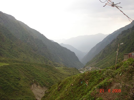
Mandakini Valley
Further up the river is Guptakashi, a village adorned with Magnolia trees and flowers. With no form of public entertainment, the village sleeps early and wakes early. On the side, the snow capped Chaukhumba is dazzling, and here in Guptakashi as in Benaras, Shiva is worshiped as Vishwanath.(figured it yet? Gupta? Kashi?). The famous saying here is “jitney kankar utne shankar”.
Image from the internet
Chaukumbha from Guptakashi

As pilgrims proceed further north, they will reach Kedarnath, and the last day’s worth of journey could only be covered on foot or horseback.
The arms of the lord are worshiped at Tungnath, the face at Rudranath, the belly at Madmaheshwar, and the hair and head at Kalpeshwar, near Joshimath. These five sacred shrines form the panch kedar.
At this point, he (we) shall leave on the glorious journey to Tungnath…


Monday, May 10, 2010

Hiking in the Grand Canyon

It's been almost two years now since I went to the Grand Canyon, but at the time I was so busy with my thesis that I never had a chance to organize my thoughts. However, quite recently, I had the pleasure of this view when I was flying from Texas to California. (There are advantages to the window seat on an aircraft as well) and it triggered a string of overwhelming memories.
I remember having been extremely excited about the trip to Grand Canyon for a number of mixed reasons, it was going to be my  last as a student, a month before graduation. It is one of the top tourist spots in the world. It was another wondrous complicity of Mother Nature. It is hard for me to say if the mountains and the river are rivals or each the best complement the other could have.
The first view of the canyons after driving four hours from Phoenix is the one that hit me in the head the most. It wasn't a simple path that Colorado had paved through the mountains. With every bit of resistance, she changed her path and continued paving ...again and again..and again. That a single river could really achieve this in-spite of an overpowering obstacle...was overwhelming.
It was close to dusk and we could not do much more than pitching our tents and cooking "bhutta" on the coal in our campfire.
 We started the next morning with a hike around the rim of the Grand Canyon and checking out the views and the geology. We were at an elevation of about 8000 ft above sea level and it never once occurred to us up there that it was the middle of the summer. The sunset was unusually disappointing because of the angle at which it sunk beyond the horizon at that time of the year. The sun hit the flat rim of the far canyon dispersing rays such that one could really see nothing much in that direction.

By now, I was a little bored  for the canyons looked pretty much the same from all around and I still was not tired as I should have been on a hiking trip. Well, the passing of the night brought a whole new day that made the trip unforgettable. We woke up at 330 am eager to catch the sunrise (scheduled at 430). If I had known that a sunrise would look just like a rewind of the sunset, I may not have made the effort. Nevertheless..it was beautiful. The dawn hue of the canyons was a sight to remember.

We hiked back to our campsite which was a good two miles, met with others who hadn't made it and began our hike on the Bright Angel's trail by 730 am. This trail starts near the  North rim, goes all the way down to the river, and comes back up on the south rim. This was only to be done over two days, and with at least two months of training. Since we only had a day, we decided to just go down a "little distance" and come back up.
There were warning signs, scary stories and gruesome pictures everywhere that warned hikers that there were hundreds of people who needed to be rescued from the trail every year because of intense heat, dehydration, stroke, bleeding and also stories of some  people who were found dead because they were delirious with heat and exhaustion, and had wandered off the trail and were lost for days.
The warnings were a good thing because even with that we got carried away. What until now was a monotonous view, now turned into an ever-changing sight. The further we descended, the canyon walls rose higher and higher and engulfed us deceptively. We were going down all the time, and hence did not give much heed to how difficult it would be to come back up(In spite of clear signs all along that said" WHAT GOES DOWN MUST COME UP" ).The views got better...we passed through different rock layers, and it still was before noon.

By the time we were 4.5 miles into the canyon, and the sun was beating down at close to 45deg C, we saw prudence in beginning our way up. It was getting hotter by the minute, and  the ascent seemed ten times steeper than the descent. We had to go back up 4000 ft. It was one of the hardest things I had to do to keep on moving. I was beyond the point of having conversation for I had no strength to spare. At every 1.5 mile stop, there was water. I had little interest in drinking it, and gladly sat underneath the tap for five full minutes every time to let my body cool under the afternoon sun. I was doing much better when it was closer to sunset and we had less than two miles to climb back up. It takes 2-3 times more  time to go up than climb down.
By the time, however, another friend had a sore foot and the going was still slow. The sun was racing against us. We were foolish to venture without torch lights and had no option but to make effort to put one foot above the other and get out before it was dark. Hiking in the dark would be a sure way of getting lost or getting bit by wildlife.(I did not mention a lunch break because we did not take any)
Just as all good things come to an end, some hard things do as well. When we came out of the trail, the sun had begun to sink, but there were still a few odd people wandering, who turned to us and welcomed us  with a cheer. We were smiling from ear to ear but were too exhausted and too parched to speak. We were also covered in dust from head to foot and could not wait to get under the shower.
Well, there was one test still left for me. After taking the bus back to my campsite, I realized that I'd lost my friend's cell phone! So the shower had to wait. It did not matter that just two minutes before , I thought that I could not walk another step...I had to do my best to find it..Luckily after an hour of wandering and talking to people, I found the phone.
The end of an adventure.